Pages

Pages

Saturday, August 29, 2009

Terry Fox Scenic Lookout

We love RV’ing and that has taken us to many rest stops on our RV adventures. They have ranged from a bit of pavement with a Point of Interest sign in the middle of nowhere to more, but most offer washroom facilities, picnic tables and perhaps some pictures of the local area. But we’ve never seen one that was as beautiful as the one at Thunder Bay called the Terry Fox Scenic Lookout.

As we drove up the street into the lookout from the highway on this very rainy day, it was like approaching an estate with groomed grass and trees and shrubs welcoming us to visit.

There is a visitor center across the parking lot as you approach the top of the drive, but it is all surrounded by trees and is restful looking place to stop to enjoy the monument, take in the view, gather visitor information or enjoy the picnic area.

Terry Fox Memorial

The walkway approach to the view took us under the trees looking to the lake, which wasn’t very visible on our visit due to the weather, but led us to the Terry Fox Memorial.

It is a beautiful monument inspired by Terry Fox, an incredible and courageous young man who touched the hearts of every Canadian on his Marathon of Hope in 1980.

We followed him across Canada as he endured the weather and hardships that the journey offered. I don’t believe anyone will ever forget his struggle and his determination to continue on with his dream of raising money to find a cure for cancer.

Terry Fox was an inspiration to all who heard his story.

This monument was designed to join east and west, has included all provincial and territorial coats-of-arms as well as the Canadian emblems of the maple leaf and beaver.

Manfred of Oakville was commissioned to produce a larger-than-life bronze replica. It stands a little over nine feet tall, weighs over half-a-ton and took more than 1000 hours of work. The finished product captures the look of determination on Terry’s face as he struggled to reach his goal.

Landscaped Garden Paths

Great thought and caring went into the design of the Terry Fox Scenic Lookout and it shows throughout the park. All those that were involved in this tribute wanted to ensure that it was as unique as the statue and as Terry as well.

Terry Fox Scenic Lookout Paths

The Terry Fox Scenic Lookout is about 12 km (7 mi) west of where Terry was forced to give up his Marathon of Hope. His legacy continues with many events held annually, this years Terry Fox Run is being held on September 13, 2009.


The Terry Fox Memorial Statue overlooking Lake Superior at Thunder Bay, Ontario, faces his Western Canada home, Port Coquitlam B.C. He is a true Canadian hero. Hopefully we will one day see his dream come true.
See more on my Kamloops blog for the Terry Fox Run, 2012.

Friday, August 28, 2009

Kenora to Thunder Bay, Ontario on our Cross Canada RV Adventure

We left Kenora late morning to head east to Thunder Bay, Ontario, we love RV’ing and we're on our Cross Canada RV Adventure and are ready for another day of seeing new country. We enjoyed the new scenery, there are lots of rocks, trees and lakes and then more rocks, trees and lakes.

We are starting to see some similarities to home in British Columbia. The highway is flanked by rock walls that the highway weaves thru, which we haven’t seen for awhile after spending time in the Prairies.


There are so many roadside lakes that we are passing by. They are on both sides of the road and I am just not able to get pictures of them all but hope to get at least a couple taken out the truck window as we pass by. And the better pictures are always on the other side of the road, so it is impossible to get that special picture !


Some lakes are tiny, some are larger with islands on them, but they are all so pretty. We understand that the fishing is great in this part of the country, too.


We do know that summer travel means road construction. For the most part, we were not held up for any length of time on Hwy 17, the traffic was kept moving quite well.
Do follow the speed recommended, for safety sake. It can be a dangerous place to be for construction workers.


Maggie is a great traveler and spends most of the time in the truck sleeping. But there are times that she decides she should help and gets on animal alert !

Kakabeka Falls


Kakabeka Falls Provincial Park is west of Thunder Bay and a nice spot to stop and stretch your legs as you enjoy the Falls. There is a boardwalk that allows you to walk from one side of the falls over the bridge and back up the other side.

Kakabeka means “thundering water” in Ojibwa. The Falls are on Kaministiquia River and drops 40 metres (132 ft) on its way to Lake Superior. Visits in the park may include camping, hiking, swimming and viewing the gorge. During winter there are 15 km (9 mi) of trails groomed for cross-country skiing and skating.


Wednesday, August 26, 2009

Kenora, Ontario, Sunset Country


We Love RV’ing, especially on such a gorgeous day as today. We had sunshine all the way from Souris, Manitoba to Kenora, Ontario. The day was fairly uneventful except for the road construction being done. We basically bounced our way from Manitoba to Ontario so there is no doubt the road we followed was in need of being repair and they were working on it for miles, many many miles. It was nice to reach our destination for the day.

The name of the town was originally Rat Portage but the change was made in the 1880’s to Kenora by using the first 2 letters of Keewatin, a sister town, Norman, a nearby village and Rat Portage. It had become a major supply and distribution center for lumber, sawmills and gold mining following the construction of the CPR and someone wise suggested they change the name. A pretty name for a pretty city.


Downtown Kenora, Ontario
What a pretty town Kenora, Ontario is. It sits on the northern side of beautiful Lake of the Woods and after the road construction scenery of the day, the lake was a sight to see, and a great welcome to town. We’d picked Kenora as a destination for an overnite stay only because it was a day’s drive from Souris, MB so we were pretty excited to see it had so much to enjoy.

Kenora has several beautiful heritage buildings about town to enjoy. We were too late to visit the museum that sits overlooking the lake, but it would be a great place to learn more about the story of Kenora. We walked down on the lakefront then around town enjoying the warm evening.


MS Kenora
The boat offers cruises around some of the 200 islands in Lake of the Woods. We arrived at the dock just as they were leaving so we didn’t go but it would have been a beautiful trip around those islands on such a pretty evening. The captain was making his announcements as they departed and said they didn’t know yet which islands they would tour so they must vary the cruise. With 200 choices you could take the cruise several times and never see the same island twice. There is no doubt that any of them would be a treat to see.


"By honoring the past, we will build our future"
There are several heritage murals about town depicting the history and they add a personal touch to the area painted by Canadian artists.

The Lake of the Woods shoreline at Anicinabe Park in Kenora, Ontario offers a wonderful area to stroll about and enjoy the water. There are several places to access the lake in the park.


The grounds are kept beautifully and have several pathways to follow, with several areas to enjoy.


The view from our RV spot.

The Anicinabe Park is where we parked our RV for our overnite stay in Kenora and it is a beautiful park. Plenty of room for camping in all kinds of vehicles. Picnic tables are sprinkled about the park, and tent sites tucked in under the trees with lots of privacy. It is right on the Lake of the Woods and offers several spots to get into the lake.


We ended the evening walk with one down on the lake at the RV park. What a serene view and great way to end the day. Now if only we had a boat.......

We're on our way for more adventures, follow along with us to Thunder Bay, Ontario.

There is a not-for-profit travel association for this region of Canada - for free travel info the camping website is http://www.ontariocampgrounds.net/ and if you would like a free guide, there is a link to an order form on that website.

Tuesday, August 25, 2009

Souris, Manitoba on our Cross Canada Adventure

Souris, Manitoba held a special interest for us because Keith’s mother’s family had been from the area so we thought we’d include it on our Cross Canada RV adventure. As life often offers us little gifts, we got a nice one as we were parking in the RV park on our arrival.

The neighbor started chatting and we told him there were family ties and he asked names, and when he heard them, he said that there were many with that name living in town. That surprised us but we also didn’t think they would be related. But they are.


                                                               Hillcrest Museum
We spent some time at their museum and found some pictures and names of family members. They were one of the founding families in the community and there are cousins still living there. The original family farm is still being worked by a family descendent.

The Swinging Bridge


Souris boasts that it has the longest historic suspension bridge in Canada, That is quite a span of river to cross. The original bridge was built in 1904, then rebuilt in 1977 after being destroyed by a flood. I did manage to get halfway across but decided there was no need to go all the way so came back to take pictures. My weak knees had nothing to do with it !

Victoria Park


We parked our RV in Victoria Park in Souris. It is a city park and includes a very nice RV park under the trees next to an arm of the Souris River, the city swimming pool is there, ballparks, nature trails and a bird sanctuary.

Peacock hiding
We saw several peacocks in the park but they were just minding their own business and none were strutting their stuff. There are about 25 peacocks, all descendants of the original 2 and are free to roam but had retreated to the sanctuary on our visit.

The bird sanctuary


The bird sanctuary is a very special part of Victoria Park. It is surrounded by water and offers a refuge where all birds are safe from predators. It was founded in the 1980’s and has grown since. It began with Canada Geese and grew to include pheasants, ducks and swans and a pair of peacocks.

Now we leave this little town and carry onto Ontario, follow us to Kenora, Ontario.

Sunday, August 23, 2009

Devil's Tower, WY to Keystone, SD - the detour continues

We Love RV'ing but we finally had “one of those days” ! We started out from Devil’s Tower on a bright sunny day and headed towards Keystone, SD, USA. The GPS system hasn’t been used much because we’ve been following the road. Now we have an RV park as a destination so Keith has entered the town of Keystone.


                                                      Devil's Tower KOA grounds

I know that GPS can be a wonderful thing but there are exceptions ! We are following the shortest route and even though I feel very competent at reading the map and navigating our trips, I have conceded to allowing Miss GPS to know what she is doing and following her directions. Let me tell you, it was not a good idea.

We followed Hwy 85 to Deadwood, SD and it is a busy little tourist town. It has a great city center and we stopped at the tourist center to get a map and some information. Then we’re back in the truck to follow the rest of the GPS directions. We head south on Hwy 385 looking to turn at Hwy 16. Miss GPS tells us to turn, which we do, and although there was no sign saying it was Hwy 16, we followed her directions of following this road for 3 miles, there was no turnout in the road for us to change our minds now. It was a single lane dirt road !! I don’t know what she was thinking ! I suggest at this point that until she is updated, we do not trust Miss GPS.

LESSON #1 – Do not always take the shortest route, it may not be the best one !
Miss GPS may have been doing as instructed, but that isn’t my department so I cannot say for sure !

Main street thru Keystone, SD, USA


We found our way out to the road, joining onto Hwy 16A getting us into downtown Keystone, SD, USA ! Woohoo, we made it. Now the key was to find the RV park.
There are directions in the book, but none of them include Hwy 16A from Keystone, so Miss GPS goes to work and gives us the directions. All other directions in our book are coming from different locations. Ok, away we go. Turns out there was a reason why Hwy 16A was not included in the book.

We wind our way thru town to follow Hwy 16A to Spokane Creek RV park. What a pretty drive, although a very narrow road, we carry on slowly with so many tight curves to navigate. There are hairpin turns, which are so narrow that we have to drive into the oncoming lane, thankfully there is not too much traffic. Even when we were on our own side of the road, it was rather amusing to see the looks on the face of the white-knuckled drivers that we did meet, but I was the only one laughing at this point.


We were crossing bridges that were built on curves, this was one windy road, but the best was yet to come.

                                                             Small tunnel opening

We found some single lane tunnels on the road, three all together, with no way around shown, we were at the point of no return and had to go through. The sign gave the size of the openings, we’re pretty sure we can fit. One tunnel was 12’ 2” high and our 5th wheel is 11’8”.

                                                              Tunnel vision
Whew, not much room to spare, we were video’d by tourists as we were going thru that one. Looking thru the end of this tunnel was framing the face of Washington on Mt. Rushmore……. That was pretty exciting, but Keith didn’t get a chance to look at that, he was busy getting us thru the tunnel ! Too bad, it was an incredible sight !

We did manage to get thru all the tunnels and made it to the RV park. I never had any doubts that Keith would get us there safe and sound, he’s driven some pretty rough roads back home without problems, but apparently there is nothing like those tunnels! Boy, was it time for Happy Hour when we got parked!

LESSON #2 - ….. update your GPS before leaving home.
Now for more fun, check out our visit to Mt. Rushmore.

http://we-love-rv-ing.blogspot.com/2009/08/we-love-rving-to-mt-rushmore-sd-usa.html

Saturday, August 22, 2009

RV'ing included Crazy Horse Monument in SD, USA


CRAZY HORSE MONUMENT

This monument does not get the same public coverage that Mt. Rushmore does internationally but it is an incredible attraction and I would recommend anyone to go to learn the story about the sculptor and how this has come to be where it is at now. It is a work in progress.


Crazy Horse Monument
The story of Crazy Horse is a great one and this monument shows the pride of the original people of the Black Hills. His quote is “My lands are where my dead lie buried”. But to me, the story is about the sculptor who designed and began this whole project. His name is Korczak Ziolkowski and he was born in Boston. He grew up in foster homes and was a completely self-taught sculptor.

The largest blast

We planned to visit it during out stay but did not expect what we saw. It just so happened that the same day we planned our visit, there was to be their biggest dynamite blast yet, 45,000 ton of rock to be blasted off the mountain. It was great to see it, even tho it doesn’t have the drama that one might expect.

The short story shown in the theater following the blast was well worth seeing. It shows some of the previous blasts, which were done at night and show the blast contrasted against the night. It also tells the story from the beginning.

A model of Crazy Horse monument

Korczak had been an assistant to Gutzon Borglum at Mount Rushmore before going off to war. He had won awards and was noticed and was invited by Lakota Chief Henry Standing Bear to make a carving as he “would like the white man to know the red man has great heroes, too”. Between the two of them, they chose Crazy Horse, who was born in the Black Hills and was partially credited with Custers’ defeat at the Battle of Little Bighorn.

Korczak arrived in the Black Hills in 1947 to accept the invitation and began in 1948. He was almost 40 and had only $174 to his name. He had to endure many hardships over the years but was dedicated to the project.

Written by Korczak Ziolkowski

Korczak was a strong believer in the free enterprise system and turned down government funding of $10 million, twice. He felt Crazy Horse should be built by the interested public and not by the taxpayer. Korszak was a man of honor, dedication, tenacity and a warrior to the end. This is not an exact quote, I had no paper to write on but in the short movie we saw, I believe he was quoting a chief who said something like, “A legend is greatness, greatness is a dream. If you have no dream, there is nothing.” I believe he lived his dream.

Tepe in the museum

Since his death in 1982, his wife Ruth works with the Crazy Horse Memorial Foundation Board of Directors and several of their ten children work on the project. There is an incredible Indian Museum of North America to be enjoyed while visiting Crazy Horse.

Check them out at www.crazyhorsememorial.org


Friday, August 21, 2009

RV'ing near Custer State Park, SD, USA

CUSTER STATE PARK

We are staying in an RV park just outside of the state park but drive thru the park on most of our trips to see the sights. The Black Hills of South Dakota have beautiful sights to offer and many animals roaming free, who seem to enjoy getting their pictures taken.

Beautiful buffalo bull


I am not sure the sound I heard from the buffalo was saying he was happy, maybe not all animals enjoy picture posing ! It was kind of a huffing sound, but maybe they just have a ‘purring’ sound like a kitten?? He is a beauty, but I kept my distance and was behind the truck and with the zoom lense was able to get what seems to be a close-up. There is no doubt that a herd of buffalo is far more intimidating than a herd of cattle.
                                            Free range buffalo go where they wish


The buffalo free range the park but people are warned that buffalo are dangerous and do not approach them. There are as many as 1500 head of North American bison, more commonly known as buffalo. They can grow to 6 feet tall and weigh more than 2000 lbs.

There is a round up done yearly and has become a great public event held in September, attracting up to 11,000 people. I can only imagine what it would feel and sound like when 1500 buffalo are pounding the trail to come to the corrals. This is when the size of the herd is adjusted, according to the predicted availability of grassland forage. The young are vaccinated and they’re all checked out by a veterinarian.


                                                                         Mule deer

Mule Deer just go wherever they want. We’ve seen them all over, especially at dusk enjoying the grassy fields, the parkland or private yards. This is a very rural area so for the most part they are doing no harm. They hop a fence with such grace and ease, and go into yards and help themselves to delicious plants, if there are any left. It looks like most people have their gardens surrounded by wire mesh. Deer are beautiful and there are plenty of them but I am sure they can be a pest at times.

Wild turkey
We didn't see a lot of turkey but they were seen scampering across the road a few times on our trip.

Mountain goat nursing her young

On one of our visits to Mt. Rushmore, we had just started up the walk of flags when there was a mountain goat, then a baby one on the hillside adjacent to the walkway. We watched for a few minutes and managed to get a picture of the baby feeding from mom. They were barely interested in all the spectators that they had, guess they’re used to that.

An inquisitive burro


We passed a herd of burros as we travelled the road. They’re very curious and not in any hurry to get off the road and out of the way. The are not to be given food, but it looks like they may just have been treated on occasion and get their nose in the window, just in case. Burros are not native to the Black Hills but are descendents of those brought here to haul visitors to the top of Harney Peak. Following discontinuation of the rides, the burros were released into the park.


                                                                   Bighorn sheep

We also saw some Bighorn Sheep who are part of the Rocky Mountain bighorn brought here once the original Audubon subspecies became extinct about 1920. Their coats consist of short hair, not wool. They are very similar to the ones we see at home in Kamloops, BC, Canada.

I think the most surprising thing that I learned was that the animal management tool used in the park is hunting programs. The fees collected thru hunting licenses help fund wildlife management programs. Species managed through hunting in the park include bison, elk, deer and turkey. The only one we didn’t see on our travels thru the parks is the elk, but they are shy and stay fairly hidden.

Other wildlife calling the park home are Whitetail Deer, coyotes, mountain lions, and bobcats. The pronghorn are often incorrectly called antelope, so we may have seen them plus the prairie dogs seen scampering across the road.

Thursday, August 20, 2009

We Love RV'ing to Mt. Rushmore, SD, USA

MOUNT RUSHMORE NATIONAL MEMORIAL

Our first day at Keystone, SD and we were anxious to see Mt.Rushmore in the flesh or granite.
We arrived on a beautiful sunny late afternoon and were impressed with the monument. There is great pride shown and with good reason. This is one of those places that pictures can not do it justice. They have a museum that shows the progress of the carvings and stories from many of those that worked on the project.


                                                       Mt. Rushmore in South Dakota, USA

One visit was planned for morning sunshine. The sunny sky was a perfect background for the great faces in granite. We spent a bit of time wandering around and I took pictures from most vantage points. The setting is beautiful. The surrounding trees have been left and offer a natural setting to walk about on the trail that leads you around the grounds.


                                                        President's faces of Mt. Rushmore, SD
Presidents George Washington, Thomas Jefferson, Theodore Roosevelt, and Abraham Lincoln are all carved in granite on Mount Rushmore.

Walk of flags


There is no fee to visit the Mount Rushmore Memorial. There is a parking pass fee of $10.00 per year. There is the museum, movies, Sculptor’s Studio, bookstores, gift shop and the Carvers CafĂ© all located on the memorial grounds.

The amphitheater


The amphitheater is the stage for the evening performance previous to the light show. The arena holds thousands of people here to view the show and all veterans in the audience are invited down to the stage to be honored during each evenings performance.

The night light show


The evening ceremony included a short movie that tells the story of the presidents being honored there. It was raining and had been for awhile so was pretty cold as well. Their crowd is usually about 3500 people but I don’t think there were anymore than 350 for that night. Then they play their national anthem while the lights are turned on to highlight the faces, it is something to see. The pictures aren’t easy to get with the conditions but I did get one.

Now follow us through Custer State Park and see the animals we saw.

Wednesday, August 19, 2009

Williston, ND, to Wyoming

We love RVing so much that we are on our 2480 km (1550 mi) detour into the USA.
We stayed at Buffalo Trails Campground, who has WiFi but we had none, even though our spot was supposed to have it. It was a rainy evening, which may have been a problem for wifi, and no satellite for TV so we spent time on our computers

Next morning, we followed #85 south on a cloudy morning. The local time is Central but we go back into Mountain Time later in the day. We decided that we’d follow ‘Our Time’, a new time zone. ‘Our Time’ is we sleep when we’re tired, ‘Our time’ is we eat when we’re hungry and ‘Our Time’ is we stop driving when we’re ready. One of the benefits of retirement and rv’ing, we’re in our own world and our own time zone !.
.
The terrain in N. Dakota south of Williston is a lot of rolling hills so there are a lot of ups and downs in the roads but they’re fairly straight. We crossed the Missouri River, although I wasn’t ready with my camera, and that was pretty.


oil rigs
There are oil rigs scattered through out the state. Right in the middle of a harvested field there will also be an oil digging operation. We’d seen lots of them in Saskatchewan and they started appearing in the Dakota’s, too.

Theodore Roosevelt National Park

We dropped down into the valley of the Little Missouri Scenic River and saw the most beautiful Theodore Roosevelt National Park. I took pictures from the truck then stopped at the viewpoint for more, these pictures do not do justice to the scenery we saw. Too many clouds make it so dark and they lose color in the photo.
Once we crossed the bridge we were entering the Little Missouri National Grasslands, and we had to stop for more pictures. Beautiful.


Field of sunflowers

We had seen several different crops in the many fields we’d seen thru the Canadian Prairies and down thru the States, but none surprised us more than the fields of sunflowers that we saw.

dummy in car

Stopped to have lunch in the RV at Amidon, ND. They had a police car with a dummy in it parked roadside at the north end of the tiny town. There was a speed limit calculator there showing your speed. The real police had someone pulled over the other end of town, a block away. The town consisted of some vacant buildings, making it look like a ghost town and with the dummy police in the car, could have been a movie but it obviously worked for catching speeders !
Home on the range

We entered Wyoming twice. Once because we were on the wrong highway, and drove into Montana, so we took the next turn and we were back into Wyoming. (It gave me two chances to get a picture of the sign welcoming us into Wyoming and I missed them both.) It added about 20 miles to the day but it also had us driving thru such pretty country and the sun had come out by then. We could say it was intentional in order to say we were in Montana, but we had done that the day before when we drove from Saskatchewan to Williston, ND.

When we got into Wyoming, the range was so pretty with the sun shining, I told Keith I had this desire to sing “Home on the Range, where the deer and the antelope play” that was going around in my head ! Then within minutes, and I am not kidding, we saw some antelope in the field. Not 2 minutes later, we saw some deer ! And basically all we’d seen all day to that point had been cattle. That is one of the strangest coincidences I have ever had.

On that same Hwy 112, we saw so many more deer we wondered if they were farming them. At home we might see two or three together, here we were seeing herds of them. We also saw wild turkeys a couple of times. We’d seen buffalo earlier and I did not get one picture of any of these animals, we were driving and weren’t able to get a photo.

Follow us on this detour into USA and our journey
http://we-love-rv-ing.blogspot.com/2009/08/devels-tower-to-keystone-sd-detour.html

Tuesday, August 18, 2009

Moose Jaw, SK, Canada to Williston, ND, USA

We left Moose Jaw on a very dreary rainy morning. The visibility was poor and the prospects of taking scenic pictures and enjoying the view were slim at the moment. We headed down Hwy 2 with the hopes of seeing some of the historic parks in the southern part of the province.

We refer to these roads we have been using as secondary roads but are in fact not considered that on the map legend. I don’t think the map writer has been on these roads. I am not complaining because we are wanting to avoid major freeways so that we can better see our great country. In many cases, we need to use these roads to get from one place to another as they are highways, but for the most part do not even have a shoulder to move onto.

That being said, the road we chose today is a major highway but has very little traffic on it which makes it easy to travel. We would go miles without seeing another vehicle, and then miles and miles before seeing another. With the prairie road being fairly flat, that meant we could see down the road a ways and were then able to move off the yellow line should anyone come, we needed the space on the narrow road, our lane was barely the width of our RV.


Hills of southern Saskatchewan

South of Assiniboia, Sask. we began to see some hills. This was all we would see of the historic parks but it was a pretty scene, even with the rain and clouds.

We would pass the occasional access road to a farmhouse but that wasn’t real often. I sure wouldn’t want to be travelling these roads in an unreliable vehicle, it could take hours to get help ! Cell service is not always available, either.

Roadside flowers


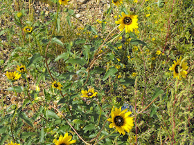
All thru the prairies, I had noticed pretty flowers that follow along the road’s edges and the edges of the crops also.. I do not know flowers well but they look like Blackeyed Susans. There is also another smaller yellow flower seen all over as well, and I am sure they’re not being planted but I decided they were there to welcome visitors. Very nice.


Black clouds over farmhouse

We were now in Montana and were seeing scenery very similar to Saskatchewan, although Hwy 16 was noticeably better at the moment. The sun was trying to shine but we saw some very threatening clouds ahead. The background for this farm was a large very black cloud.

Medicine Lake Conservation Park

Medicine Lake Conservation Park was on both sides of the highway as we passed by with beautiful but dark clouds in the west. We haven’t been able to hear a local weather forcast but only hope the clouds open up for us and clear the way south.

Welcome to North Dakota

The roads of Montana were no longer good. We were now on Hwy 2 and came upon road construction that went on for miles and miles. I would guess it was about 10 miles of dirt road, parts of it very muddy from the rain and slow going pulling the 5th wheel. We were to follow the pilot car but that was impossible, he was going too quickly for the road conditions. The pilot car was only for the first couple of miles, and it was Sunday so the road crews weren’t working so we were on our own for the rest of the construction site and that was fine.

It was a great site to see the sign welcoming us to North Dakota and the construction ending here.

We’re nearing Williston, N.D., USA and will spend the nite there.
Follow us on our 2480km (1550mi) detour, into Williston and beyond.

.