Pages

Pages

Monday, July 25, 2016

Northwest Territories - Fort McPherson - Mackenzie River

Another summer day in the Yukon with a 9:00 am temperature of 16C is not a bad start to our travels today.  The clouds come and go all day with some sunny breaks but no rain, and that makes for a good day with dry roads on this 500 mile gravel trek up the Dempster Highway.

The Dempster Highway

We saw no wildlife but we did see some ptarmigan on the roadside with some photos of flight but not easy getting birds in flight out the window of a moving truck. 
A Pingo
We came upon a pingo which is a unique arctic landform.  The word pingo translated is ‘hill’.  Farther north there is a designated Pingo Canadian Landmark area which features eight of the 1350 pingos found in the area. They were used as a navigational tool for early travelling as well as a convenient height of land for spotting wildlife in flat tundra areas.

We enter the Northwest Territories
We have now entered the Northwest Territories and this point is called the center of the world.  Birds arrive here from all over the world to breed and nest during the long daylight hours of the season.

Incredible sights of green hills 
The ground here only thaws to about 25-40 cm (10-15 inches) in the summertime, but frozen solid most of the year.  The ground below that never gets above 0C (32f) and that stops the water from draining from the root zone.  We can enjoy green scenery due to this.

Peel River ferry crossing
We arrived at the Peel River and were able to cross it on the ferry with no problems.  Only a few days earlier in Dawson City, we’d learned that the ferry was closed due to flooding of the Peel River but all was well when we got there.

Nitainlaii Territorial Park Tourist Info
We stopped at the Tourist information in this log cabin which was full of photos and story boards but no one there to speak with.  We signed in then had a look around and with some brochures in hand, moved onto Fort McPherson.

Church in Fort McPherson, NWT
We stopped to visit the small town of Fort McPherson which is the oldest permanent community in the Mackenzie Delta. The Hudson’s Bay Company established a trading post here in 1840 offering conveniences of that time available. The Gwich’in continued to move their families to hunting and fishing camps until the 1950’s when they were required to get an education and then settled more permanently in this community.  

Parked at the Mackenzie River
One more ferry crossing today and we parked on the shores of the Mackenzie River across from the small traditional Gwich’in community of Tsiigehtchic.  The Mackenzie River Arctic Red River ferry is free and operates daily from June to mid-October, then the river is crossed by ice bridge the rest of the year.

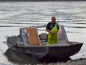
Mackenzie River fisherman
We gave a friendly wave to a passing boat and he turned around and came for a visit.  We called him “Seagull” as he was being followed by many of them.  He then told us how his grandfather called him that same thing when he was a young boy.

Dinnertime
We were interested in his catches of the day, but he may also have had a motive to stop.  ‘Seagull’ sold us a fish.  After some persuasion, he also filleted the fish and was then on his way.  We all enjoyed a delicious dinner freshly caught from the Mackenzie River.

Maggie and the birds
The seagulls and crows enjoyed the remains of the filleted fish while Maggie kept a close eye and we all enjoyed our evening on the shores of the Mackenzie River.

Wednesday, July 20, 2016

Arctic Circle ~ Dempster Highway ~ Yukon

This is our second day on the Dempster Highway in the beautiful Yukon country and we drive just short of 200 km (120 mi) today.  The roads are gravel but although some places are good road, not all of them are. Our speed is slow most of the time, we spend about 8 hours of our day driving.

Ogilvie River morning fog
We woke up to a beautiful sunny morning at Elephant Rock and enjoyed our morning coffee beside the Ogilvie River.  We were usually on the road by 8:30 am but we weren’t in a hurry this morning and didn’t leave until 9:30 am. 

Ogilvie Mountains
We stopped at each viewpoint we came to.  The day was beautiful and the sights were spectacular.  Ogilive Ridge – Gwazhal Kak, which means “swollen up” was at the top of a seven mile hill.

Ogilvie-Peel River system
This view reaches 180 km (112 mi) over the Ogilvie-Peel River systems.  The Ogilvie River is one of 6 rivers that flow from the Ogilvie Mountains into the Peel River in the low lying plateaus.  These six tributaries run into the Peel River, part of the McKenzie River watershed, which is the  largest one in Canada.

Fireweed overlooks the Ogilvie-Peel plateau
The Peel River is 440 kilometres (274 mi) long and the watershed is crucial for the habitat living in the area.  It would be interesting to see what lives out there in the valley but we weren’t about to go down there to find out.  The fireweed, Yukon’s national official floral emblem frames the view of the valley beautifully.

RV wash at Eagle Plains
We stopped at Eagle Plains, the halfway point that has a population of 8!  It is a good place to stop for fuel, lunch and even wash the RV’s to remove some of the mud on there.   There is a hotel that is open year round as well as a restaurant where we enjoyed a good lunch.  That is all there is.

Dempster Highway, Yukon
Midday temperature was about 16C (60F) and we are on our way again with cleaner vehicles and full tanks.  The green mountains and valleys continue as we cross the Eagle Plains and make our way north.  We are between the Ogilvie Mountains to the south of us and the Richardson Mountains to the north.  The great views continue!

Airstrip on the Dempster Highway
They say there is a first time for everything, and this was definitely the case with this sight.  This stretch of road is also used as an airstrip!  The sign tells us there is no stopping or parking on this road.  I doubt its a busy strip but when someone needs to land an airplane up here, this is the place to come.

We are at the Arctic Circle in Yukon
We have arrived at the Arctic Circle!  There is a large rest area at this point and this is where we will stay the night.  We make this our night stop both times we travel the Dempster Highway.

Richardson Mountains
With no one else here, we park and put our chairs outside to enjoy the amazing view.  A young couple who we’d spoken with at Eagle Plains stopped and had a visit before they moved on.  The wind was pretty strong but there were no mosquitoes to deal with. 

Storm is coming to the Arctic Circle
We sat outside and watched the lightning show as it made its way toward us before the storm forced us to go inside.  The rain passed over and by 10:30 pm the bright sun was shining again…..at the Arctic Circle!

Monday, July 11, 2016

Dempster Highway ~ Ogilvie River ~ Yukon

Today was the beginning of our travels up the Dempster Highway, very famous for its rough terrain and potholes.  We are prepared with extra tires and supplies as we set out to travel 737 kilometres (458 mi) to Inuvik, NWT.  

Rainy Dempster drive
That mileage begins once we reach Hwy 5 after driving 64 km. to the junction from Dawson City, Yukon.  It is very rainy and wet so the view will be limited until we get past this part of the day.  Our temperature was 12C (53F) midmorning with very little improvement in the weather all day.

Muddy Dempster Highway
This was the weather for much of our day so we were not getting to see the great views.  It was on our return when the weather was better that we saw some incredible scenery and I will also share those photos here.

Tombstone Interpretive Centre
The Tombstone Interpretive Centre is about 70 km up the Dempster in the Tombstone Territorial Park and we made a stop here to have a look around the Centre.  It is very interesting with lots of history and information.  The building itself is also unique as it is ‘off the grid’ and exceeded the standards set by Canada’s Green Building Council.

Cow moose and calf
Our next stop was at Two Moose Lake where we had some lunch but as much as it is named due to the fact that moose hang out here, there were none.  Back on the road again and we later saw a mother and young moose running across a distant field. They are tundra moose, the largest in North America.

Ogilvie Mountains
Our return trip definitely gave us better views.  We did have clouds and some rain but nothing like we had coming up this way the week before.  It took us four days to reach Inuvik and after our stay there it took three days to return to Dawson City.

Fireweed lines the highway
There are few camping parks along the way but we did stop at Engineer Creek Campground.  It was filled with big trees so was a dark park.  It was still raining so hard and although we had not seen any mosquitoes up to this point, there were gazillions of them here.  We didn’t even get out of the truck and decided rather quickly we would move on.

Gyrfalcon and nests
We were able to see some nesting gyrfalcons high on the rocks.  We had read they would be here, but unless one knew to look, they’d be very hard to see.  Thankfully, our leading guide with the ‘eagle’ or shall we call it ‘falcon’ eye, spotted them.  They are the largest falcon and are a bird of prey.  The female is the largest of the two and they breed in the Arctic and tundra.  It was quite a thrill to see them.

Beaver dam in roadside pond
We saw several beaver dams on our travels, and they all seemed so big.  It would have been nice to see a beaver but that didn’t happen.  What we did see was a peaceful looking lake along the roadside.

Elephant Rock
There was a pull out called Elephant Rock rest area on the side of the road with no one else there so we parked our vehicles and stayed for the night.   The camera lens could not see it but with the help of a telescope, I was able to get a photo of Elephant Rock!

Fishing on the Ogilvie River
We were right on the Ogilvie River so there was some fishing done.  The fishermen had some luck but did not keep any fish as it was ‘catch and release’.  This turned out to be a great stop, no rain and no mosquitoes!  We had a campfire going and enjoyed the peaceful evening watching the river pass by.

Midnight Sun
The time went by and before any of us realized it, it was almost midnight!  And the sun was shining on the mountain across the river.  Sure could not miss a photo opportunity like this.

Day one on the famous Dempster Highway was completed and we did not have one flat tire.  It was a great day in spite of the rain but thanks to that, we sure did pick up a lot of mud on our vehicles! Wasn't the first time and wouldn't be the last, either. 

Join us as we carry onto the Arctic Circle.

Monday, July 4, 2016

Dawson City ~ Gold Rush ~ Yukon

Dawson City is a designated National Historic Site and rightly so.  A visit to this city takes you back in time to the Klondike days of the gold rush and the life that was all part of that.  Many of the buildings have been restored or refurbished and offer a realistic and colourful display of the past.

Downtown Dawson City, Yukon
There was nothing here previous to the gold strike in 1896 but when that became public information in July 1897, Dawson became a city almost overnight.  6.000 people arrived before winter came with thousands more to follow which started the gold rush of 1898.  Dawson City soon had a population of 30,000 people. The current population is 2,000.

Perma frost results
These buildings were built in 1901 and originally a hotel, photography studio and a hardware store.  They’ve been left in their natural state to demonstrate the progressive effects of having heated buildings on permafrost ground.  Permafrost damage rates the second most destructive only to fire.

Miner's tribute Dawson City River Walk
We spent some time at the Dawson City Museum which is in a beautifully restored old administration building.  It had some very interesting displays plus we watched an award winning “City of Gold” film narrated by Pierre Berton in their theatre.

Klondike Spirit on Yukon River 
The Klondike Spirit is the only paddle wheeler operating in the Yukon.  It began in 2007 and offers historically narrated tours with dinner.  Most of the river boats of the past were sternwheelers and although both were powered by steam engines, those paddles were at the rear or stern of the boat.

View from the Dome
The Dome is the place to visit to see the spectacular view of Dawson City and the Yukon River below. Our visit was during some seasonal wildfires in Alaska and smoke along with the clouds may have been slightly distracting, but it was a great view.

Yukon River from the Dome
As is still done today, the first group of 150 visitors came up to the Dome to watch the midnight sun at the summer solstice June 21, 1899.  To their disappointment, the sun set one half hour before midnight and rose two hours later.   The Dome still remains a popular spot to celebrate long summer nights.

Diamond Tooth Gerties
One of the busiest places in town was Diamond Tooth Gerties.  This is a casino and did have the modern day slot machines in there but the best part and what brought us here was the live show in the old fashioned hall with “Gertie” a great singer and entertainer and her showgirls, who kept the energy high.
Robert Service Cabin
Robert Service left this rented cabin in 1912 but it soon became the Yukon’s number one tourist attraction, it symbolizes the legacy of the Klondike Gold Rush.  Jack London lived in Dawson City in 1897/98 to prospect gold but due to scurvy had to leave.  He later became a famous author with his many books based on life in Alaska.  Pierre Berton, a famous Canadian historian and author lived in Dawson City until he was 12 years old then went back and worked in Klondike mining camps during his university years.  Each of their homes are historical sites in Dawson City, Yukon.

Dredge #4
A dredge is a floating sluice plant used to dig for gold.  We went for a tour of the largest gold digging machine of its kind in North America, out at Bonanza Creek, where the famous gold rush began.  The Dawson City area mined 88% of all gold mined in Canada and Dredge #4 recovered 8 metric tons of that gold over 46 year period.

Bonanza Creek Tailings
The sight that greets us just outside of Dawson City is the tailings that are the result of the early mining days.  They are the waste that is left after the gold has gone through the many screens and sluices.  Not the least bit attractive, but they are part of the story of the Klondike gold rush days. 

We are on our way up the Dempster Highway when we leave Dawson City, click here, so much more to see.